Showing posts with label hiking. Show all posts

Friday, March 27, 2009

Iron Mountain Natural Area


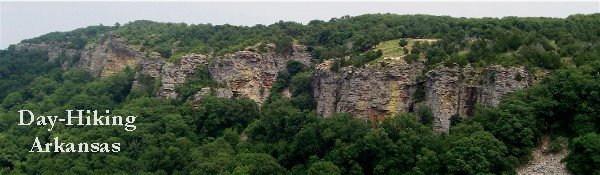
Iron Mountain Natural Area is a little known area located southwest of Mena, Arkansas. This 261 acre natural area is managed by the Arkansas Natural Heritage Commission. The ANHC manages 63 different areas in Arkansas. These "islands" preserve Arkansas' native habitat as well as provide many recreational opportunities.

The Iron Mountain Natural Area is one of only five natural areas that contain hiking trails. The trail is a 1.5 mile loop that follows a small stream (Paul Branch) which bisects the natural area.

It was a cloudy day when my wife and I visited Iron Mountain. After parking at the trail head along County Road 169, which is bordered very closely by private property, we began our hike. There appeared to be quite a bit of work going on within the natural area. There were several survey markers and flagging around the trail as well as obvious signs of trail maintenance. The trail was well marked by blue plastic diamond shaped blazes.

A short distance from the trail head you will reach Paul Branch where the trail splits. To the left the trail continues along beside the stream and to the right it crosses Paul Branch and continues uphill. As you will have to cross the stream here on your return and at the mid point it would be a good time to judge whether or not to cross downstream or circle back, depending on the water level.

Continuing left, the trail is fairly level. There are several narrow spots due to erosion and lots of small hops over tributaries of the stream. Old ATV trails intersect the trail at several places and in wet weather could cause for some wet feet so be prepared.

The trail passes through the typical pine, oak, and hickory forest. There is also the occasional cedar mixed in as well. The one constant along the trail is the sight and sounds of Paul Branch. As you follow the trail downstream you are constantly rewarded by the soft soothing sounds of the running water and picturesque beauty of a mountain stream.

The stream widens as you pass through a grove of cedar trees and begin a more uphill hike. There are some low branches and trees down in the corridor but nothing that isn't easily avoided. The trail finally reaches an older road at the north border of the natural area as the trail swings downhill to the right. As we approached the stream, we were treated by the sight of a woodpecker vigorously working for some food on a nearby tree. He was busy at his work and didn't mind the two onlookers staring up at him.

You will cross the stream at this point. There is a wonderful little rock formation nearby which makes a nice spot to stop and picnic or just relax to the sounds of the running water.

The trail heads south along the opposite side of the stream from this point. This part of the trail has many more trees and branches in the corridor. Several of the blazed trees have fallen and with the debris in the way it can be sometimes hard to make out the trail. There are a lot more ups and downs also, making this section more moderate.

There will be a large uphill climb towards the end. Watch your footing, especially downhill, as the fallen leaves conceal hidden rocks and small holes which could cause a fall. You will eventually arrive back at, and cross, the stream where it had split in the beginning of your hike. After that simply follow the trail in reverse back to the trail head. Of course most of that will be uphill. =)

The best times to hike this trail would be in the spring and fall when Paul Branch is running. The colors of fall and the wildflowers of spring also add to an enjoyable hike. With the numerous places for water to collect I would avoid this trail during the warmer months when the bugs will be out.

Directions:
From Mena, travel approximately 7.1 miles southwest on U.S. Highway 71 through and beyond Potter Junction. Turn right on County Road 168 and travel 0.2 mile to fork. Turn right on County Road 169 and travel 0.3 mile to parking area on right.

Length: 1.5 mile loop
Difficulty: Moderate (this could lower as more trail maintenance is completed)
Scenic Beauty: 3
Child Friendly: Children under eight will need help in certain places. Older children should be fine.


Thursday, March 12, 2009

Almost Spring

It seems odd to be thinking of spring while snow falls outside, but the official beginning of spring is only seven days away. But while we can look forward to warmer temperatures, wildflowers, and the numerous other treats which delight outdoors adventurers, there is also the inevitable appearance of all those bothersome insects. Ticks and chiggers being by far the worst. While hiking I always remind our kids that bothering wildlife (ie. chasing squirrels, throwing rocks at snakes, etc.) is against our outdoor ethics. Ticks however, are fair game.

My wife and I have been enjoying the recent weather and have used the opportunity to dayhike some local trails which has been fantastic. Those combined with some searches for geocaches located in wonderful areas has allowed us to hike at least twice a week.

We were fortunate to visit Hole In The Ground Creek Falls. It was actually a set of waterfalls located down an old ATV trail north of Pencil Bluff. The scenery was outstanding. We spent quite some time enjoying the area and sat down to have lunch beside the upper falls. It was great. Our round trip distance measured by GPS was 3.03 miles.

Three days later we ventured into the Poteau Mountain Wilderness to visit Slate Falls. The hike along the old road was easy but we were disappointed that the falls were all but dry. Still getting to see the height of the falls and explore around the remains of the old stone dwelling made the trip more than worth while. Of course we hunted for and found the geocache Slate Falls while we were there.

On March 4th we were delighted to get another chance to go hiking and this time we chose to hike Hole In The Ground Mountain Trail. It's hard to describe how wonderful this trail is. Being located south of Booneville, with a trailhead at Jack Creek Recreational Area and the Dry Creek Wilderness, this trail is a seldom visited jewel in the Ouachita Forest. It isn't for the timid though. The trail can be challenging in places and is rough in others. Sometimes both. We tried to begin our hike from the Jack Creek trailhead but my wife didn't want to have anything to do with crossing the frigid flowing creeks. So we drove to the other trailhead and hiked in from there. One of my favorite parts of the trail are as you summit and cross over Hole In The Ground Mountain. The Pine on the west side of the mountain quickly gives way Black Oak on top and then Cedar as you move down the east side. The transition is so quick it is almost instant. There are also abundant geological formations and views along the way. I strongly encourage anyone who can to visit and enjoy the trail. You won't regret it. We flip flopped and got a total of 5.7 miles in that day and wished we could have done more!!

Monday brought about a doctors appointment in Poteau. That's a long drive and we stopped by Subway to grab some lunch on the way home to celebrate my 25lbs I've lost so far on my diet. We decided, spur of the moment, to hike at Runestone State Park in Heavener. It is kind of shocking how little trail maintenance is done there compared to our state parks. Yet another reason Arkansas is awesome! We hiked for roughly a mile by combining two trails ad enjoyed the views immensely. The picnic pavilions at the park have hang glider shaped roofs which was really neat.

The next morning, Tuesday, after the kids were off to school my wife asked me if I wanted to go for another hike. Oh Yeah! I was ready to go! :-) We decided to combine some geocaching along with our hike. We went to Knoppers Ford Recreational Area and hiked the Sugar Creek Hiking Trail. It was really warm when we started from the trailhead. The views of Sugar Creek were beautiful and initially the trail was clear and easy. Once you get about 0.5mi from the trailhead the trail gets rougher though. Again from lack of maintenance. Some blowdown had been there so long that the spur around it was more prominent than the trail itself. That notwithstanding, the trail was great. I enjoy hiking on seldom used trails. You never see another soul and have the woods all to yourself. We hunted for four geocaches along the way and enjoyed a picnic when we reached Middle Creek. By looping back we manged to hike 3.6mi in total. We did see three snakes (a ringneck, a kingsnake, and a cottonmouth) along the way. Of course with the warmer weather those little parasitic spawns of evil were out also. I hate ticks! But on the plus side, tick checks can be fun. ;-)

We've made plans to hike some more trails in the Brushy Creek Trail Complex this Sunday. We were going to do it Saturday but this cold and rain weather will still be here. Sunday should have temperatures in the 60's so it will be great. We're going to build a campfire in the camping area afterward and roast some hot dogs and marshmallows. I'm bringing our fishing poles to try our luck while we're there. The whole family is really looking forward to it and it should be a fantastic day.

The Ouachita National Forest offers so many things to do and see I don't think anyone could see it all if they spent a lifetime exploring it. I am sure that the attempt itself would be rewarding beyond measure. Arkansas offers so much to do. I feel blessed to live in such a wonderful state and being able to watch my children explore the natural world around them, knowing they will be able to share it with their children.


Tuesday, April 1, 2008

Scout Falls


This is a little late but it has been so busy here. I finally got the time to write about our little adventure.
On the 20th my wife and I decided that with the kids in school that day it would be perfect to go and hunt the Slate Falls cache (GCRRD0). There had been a record amount of rain recently and had even stormed the night before so we were excited at being able to see the falls flowing.
We hadn't traveled far up Poteau Mountain road when we met some Forest Service workers clearing debris from the roadway. They told us that due to seeing some other vehicles heading the other direction that they thought the road was clear ahead. Well, after driving a few miles we sure enough met with a large tree blocking our progress.
Another Forest Service worker pulled i next to us a short while later and together we waited for the work crew to reach us.
As we waited, she told us about a cave nearby known to locals as "Belle Stars Cave." It was also known as the boy scouts cave as they used to camp there in the 40's and 50's and had even built a rock fireplace for warmth inside the cave. She told us how to reach it and after seeing that we wouldn't have time to reach Slate Falls we decided to visit the cave.
We began our hike from the road and hiked down the mountain to rock creek. With all the recent rains it was REALLY flowing, enough to take your feet out from underneath you if you weren't careful, and it was cold! After crossing the creek it was a short distance to the cave and suprisingly a wonderful 20+ foot waterfall!!!
The whole area there is a protected archaeological site. We explored the cave behind the falls for quite some time and even hiked further down for awhile just to see what was there. Time was getting short though so we had to haul back up the mountain which was rough.
My wife and I had a wonderful time and we plan on returning later. We found another trail leading in from the North that hold who knows what treasures.